B. Losson (1) and Y. Quinif (2)
(1) Centre d'Etudes Geographiques de l'Universite de Metz (CEGUM), Laboratorie de geographie physique, Ile du Saulcy, 57045 Metz Cedex 1 ( France)
(2) Centre d'Etudes et de Recherches Appliquees au Karst (CERAK), Faculte polytechnique de Mons, rue de Houdain, 9, B‚7000 Mons ( Belgium)
Abstract
The Moselle piracy is one of the most important changes of the hydrographic network in Lorraine ( France). For a long time, this phenomenon has been presumed to be relatively recent (at the end of the Middle Pleistocene) because of the well-preserved fluvial morphologies and deposits. With new relations between the surficial and subterranean data in the piracy area, the capture has been dated from 300ka using U/Th method on speleothem. This evaluation reveals an earlier time for the phenomenon, and is more precise than those proposed up to now. The latter were derived from the North-European glacial chronology and one thermoluminescence date obtained in the downstream valley of Meuse. In fact, the improvements in absolute dating, thanks to different methods and U/Th in particular, lead geomorphologists to abandon the simple relation between the glacial-interglacial periods and the accumulation-erosion processes in rivers.
Keywords: Moselle piracy, Fluvial deposits, Speleothems, U/Th dating, Haye caves
Introduction
For a quarter of a century, the unequalled development of the absolute dating ( 14C, U/Th, K/Ar) has highly contributed to the progresses in paleogeomorphology. The classical chronological outline for the Quaternary, based on the Alpine or North European glaciations, has been better established in time. However, the Quaternary phenomena and deposits are more often set back in an isotopic stratigraphy (isotopic stages of Emiliani, 1955). In the field of the valleys change, the relative chronologies always prevail, because of the lack of chronological information from the alluvial deposits. The regular entrenchment of rivers, recently reassessed by some authors (Macaire, 1990; Quinif, 1999), encourages to review the simple causal relations between glacial-interglacial periods and fluvial terraces (Conchon, 1992). At the same time, the temporal setting of the hydrographic reorganizations by captures is itself concerned with this difficulty to make the correspondence between the alluvial levels and the North European chronological outline.
On the occasion of a research about the influence of the karst on the Moselle piracy ( Lorraine, France), the dating of speleothems by the U/Th method (Quinif, 1989) was seen as a reliable way to refine the capture time. The determination of the genetic relations between the alluvial deposits and the cave systems of the Moselle valley yields, by successive interdependencies (Fig. 1), to a chronological framework for the Moselle piracy, based on U/Th dating.
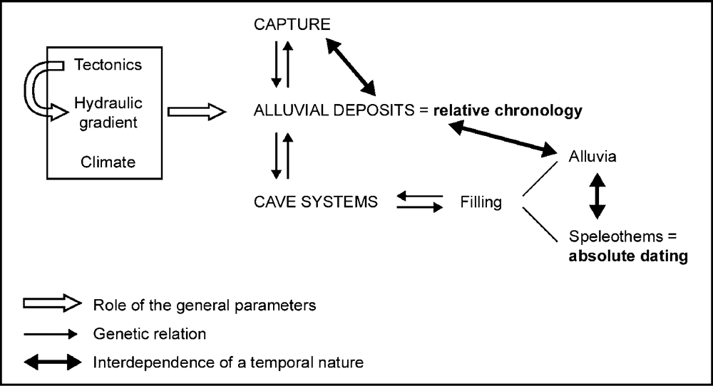
Fig. 1. Relations between the geomorphologic data of this study, leading to the different interpretations.
The Moselle hydrographic network geosystem is under the influence of geologic and climatic parameters, thus morphological too. The Moselle piracy phenomenon is linked by feedback effects to the fluvial sediments, which themselves have been generated in the relationship with the local valley cave systems and their filling. These successive genetic relations allow to establish some chronological links between the stratigraphic and morphologic elements that make up the system. The main link is caused by the existence of surficial and underground alluvia that we can corroborate. Considering this fact, the absolute dating of speleothems will allow to establish minimal ages for each alluvial deposit. And the same will be true of the hydrographic diversion, set by the relative chronometer constituted by the Moselle alluvial deposits.
1. Main features of the relief of the studied area
1.1. General geomorphologic context
Two main rivers govern the drainage pattern of Lorraine: the Moselle and the Meuse. Coming from the Vosges, the first one heads for the second one as far as Toul, where they are only twelve kilometers apart, before diverging to join the Rhine. Formerly, the Moselle was flowing in the Val de l'Ane, west of Toul, before meeting the Meuse at Pagny (Figures 2 and 3; Photos 1 and 2). The actual acute bend made by the river is the result of a capture, well studied for more than one century (Davis, 1895; Blache, 1939-1940, 1943; Tricart, 1952; Harmand, 1992; Gamez et al., 1995; Harmand et al., 1995c; Le Roux and Harmand, 1998; Harmand and Le Roux, 2000). The site of this hydrographic diversion encompasses two cuestas systems (Figures 2 and 3): the Moselle cuesta, on the east, made up of Toarcian marls and Bajocian limestones; the Meuse cuesta, on the west, with Bathonian-Callovian marls and clays, and Oxford limestones.

Fig. 2. Simplified cross-section through the Meuse and Moselle cuestas.
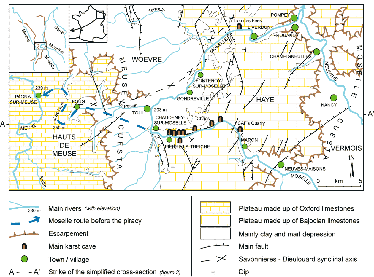
Fig. 3. Morphostructural sketch of the "Boucle de la Moselle " (from the geological maps of Toul and Nancy at the scale of 1/50,000).
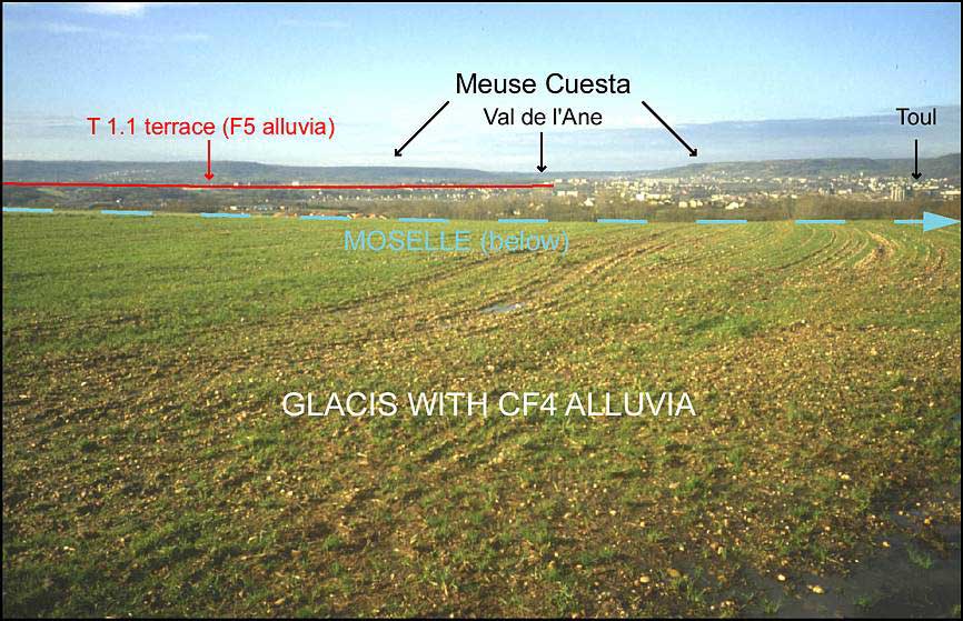
Photo 1. The cataclinal paleovalley of the Moselle in the Oxfordian Escarpment, seen from the old fort of Dommartin-les-Toul to the west (snapshot B.L.).

Photo 2. The abandoned Paleo-Moselle valley through the Hauts de Meuse (Val de l'Ane), seen from the Ecrouves plateau (snapshot B.L.).
In addition to the alternation of depression - scarp face - dip slope, the local relief is marked by the Moselle valley, deeply entrenched in the Haye plateau (cataclinal and anaclinal branches, to the south and the north respectively; Photos 3 and 4) and much more widened in the orthoclinal depression of the Woevre. Two geomorphologic features correspond to this fluvial axe: a lot of alluvial deposits all along the Moselle stream and its paleocourse towards the Meuse; the presence, on the valleyside, of "died" cave systems (Fenelon, 1968), which shows a decreasing stepping from east to west, in accordance with the general dip. Some marked genetic interactions exist between these two parameters, as will be shown. But before, let us examine more precisely their characteristics.
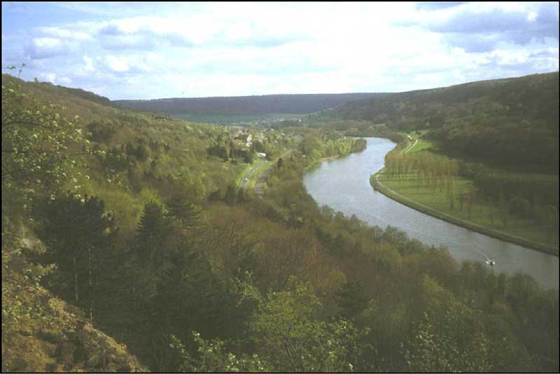
Photo 3. The cataclinal valley of the Moselle at Maron, seen from the entrance of the CAF's Quarry Cave to the south; on the right, the wooded plateau, which dominates the river over 100 m high, is covered by old alluvial deposits CF7 to CF10 (snapshot B.L.).

Photo 4. The Moselle anaclinal valley, seen from Liverdun to the west. In the foreground, the first loop of the meander has been straightened by the canalization of the river (snapshot B.L.).
1.2. The fluvial deposits of the Moselle
In the geomorphologic context of a stream piracy, the fluvial deposits of the Moselle are already studied for a long time. The story of these investigations can be split up into three stages: first, selectively, with the intention of giving arguments for the diversion, i.e. mainly in the Val de l'Ane and along the Meuse valley (Buvignier, 1840; Husson, 1864; Vidal de la Blache, 1908; Nickles, 1911; Martin, 1920); then, from a spatial and altimetric point of view (Gardet, 1928; Theobald and Gardet, 1935; Errard, 1942); last, and more recently, about the river deposits as such (Dangana, 1970; Vaskou, 1979; Taous, 1994; Techer, 1995; Harmand et al., 1995a; Dorniol, 1997).
Some works are still under way for the determination and the differentiation of the fluvial levels, but on the whole, we can note the following characteristics (Harmand et al., 1995c; Pissart et al., 1997; Harmand et al., 1998; personal unpublished observations) (Fig. 4):
- residual old alluvia exist above 250 m high (in the study area): the detritic deposits (CF) have been strongly reworked and do not yet form fluvial terraces s.s.;
- real terraces, as well as the actual flood plain, can be seen below 250 m high: their alluvial deposits (F5 to F0), still often thick and not reworked, have been the subject of petrographic counting whose results vary from one author to another, in their meaning for the differentiation of the diverse deposits.
Note that the names F5 to F0 correspond to Fx1 to Fz of Harmand et al. (1995a), but we will only use the former nomenclature in the following text, so as to free ourselves from the North European chronological notion, defined by the small letters. Let us remind above all that the alluvial deposits F4 date from before the capture, whereas the F3 one are posterior to this event (Harmand et al., 1995a). The hydrographic phenomenon probably occurred at the end of the F4 aggradation.
Fig. 4. Location in elevation of the Moselle alluvial deposits near Pierre-la-Treiche, of part of Sainte-Reine and Shafts Caves (developed cross-sections) and of some other main cave systems in the cataclinal valley.
1.3. The cave systems of the Moselle valleyside
The second important geomorphologic element, although not very visible in the landscape, is the cave systems found all along the entrenched Moselle valley in the Haye plateau. Most of the known caves open onto the sides of the cataclinal defile and in particular at Pierre-la-Treiche (Fig. 3; Photo 5). The main cave systems come down to five caves (Louis and Lehmuller, 1966) (Figures 4 and 5): Chaos Cave (about 240 to 270 m high above sea-level), 7 Chambers Cave (about 210 to 230 m), Sainte-Reine Cave (about 210 to 225 m), Jacqueline Cave (about 205 to 225 m) and Shafts Cave (about 215 to 235 m). Besides these main caverns many other ones exist with far more limited developments, like the CAF's Quarry Cave, at an elevation of 295 m. Following numerous morphosedimentary subterranean observations, the same genesis can be proposed for all this valleyside endokarst.

Photo 5. The Moselle valley at Pierre-la-Treiche (snapshot P. Gamez).

Fig. 5. Pierre-la-Treiche cave systems on the right bank of the Moselle (from Louis and Lehmuller, 1966; Louis, 1988).
2. Genesis of the cave systems of the Moselle valley: development and relative temporal aspects
2.1. Conditions of cave systems development
The caves in the Haye plateau present all the characteristics of a subfluvial karstification (Gamez and Losson, 1998; Losson, 2000): exclusive location of the cave systems close to the sides of the Moselle valley, and a near absence of penetrable cavities, with no fluvial influence of the Moselle (or the Meurthe); marked prevalence of cave macro- or micromorphologies in flooding conditions (maze of bedding plane anastomoses, eroded joint patterns, withdrawing chimneys, pockets in the three dimensions of space, scallops which indicate that the paleoflows came from the Moselle thalweg to the interior of the massif, ceiling channels) (Photos 6 to 13); considerable filling, made up mainly of alluvial deposits of Vosges origin (Photos 13 and 14), and petrographic analogies of these detritic deposits with the surficial alluvia of the fluvial terraces, just above the caves (cf. Photo 5).

Photo 6. A view of the Eastern gallery of Sainte-Reine Cave: this pipe was created at the meeting point between a fracture and a bedding plane (snapshot B.L.).
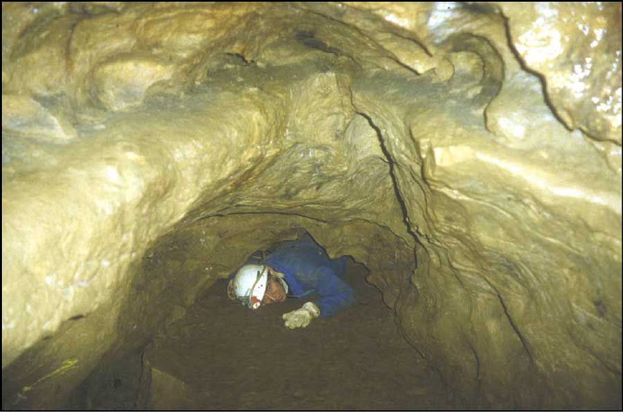
Photo 7. The " Passage de la Tete de Renard " ("Fox Head Bottleneck ") (probably a former siphon), in the Western gallery of Sainte-Reine cave (snapshot B.L.).
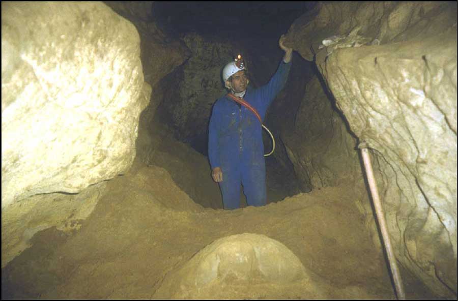
Photo 8. A view of the Western gallery of Sainte-Reine Cave: more spacious, on the whole, than the Eastern gallery, this one is nevertheless filled with a lot of Moselle alluvial deposits (about 4 m thick here) (snapshot B.L.).
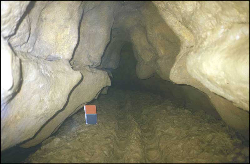
Photo 9. Typical pipe of the eastern part of Sainte-Reine Cave: the northern connection gallery (notebook = 17 x 11 cm) (snapshot B.L.).
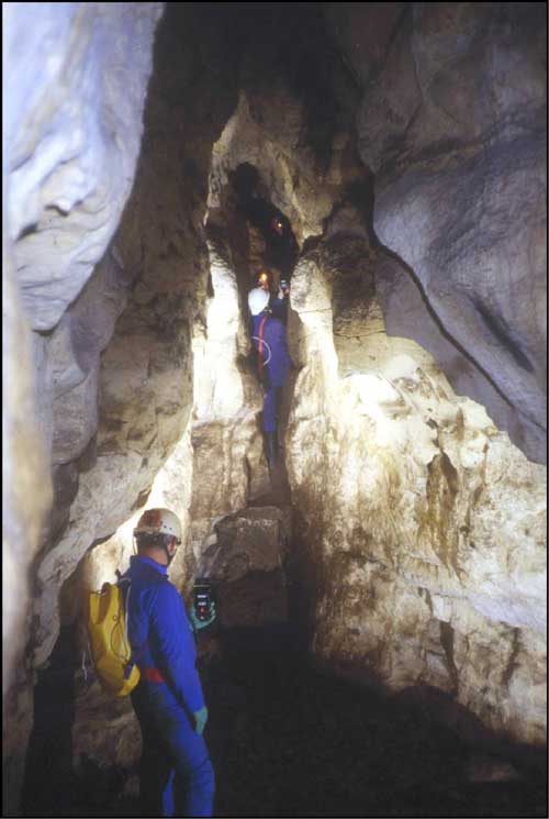
Photo 10. The entrance gallery of Shafts Cave, developed along a joint (snapshot P. Gamez).

Photo 11. The Shaft 1 of Shafts Cave; it is a " pseudo-shaft " (vertical pipe) developed on a fracture in the phreatic zone (snapshot P. Gamez).
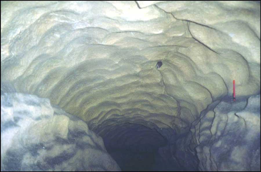
Photo 12. The ceiling of the western Lower Gallery of Shafts Cave, displaying scallops (southward view) (snapshot B.L.).
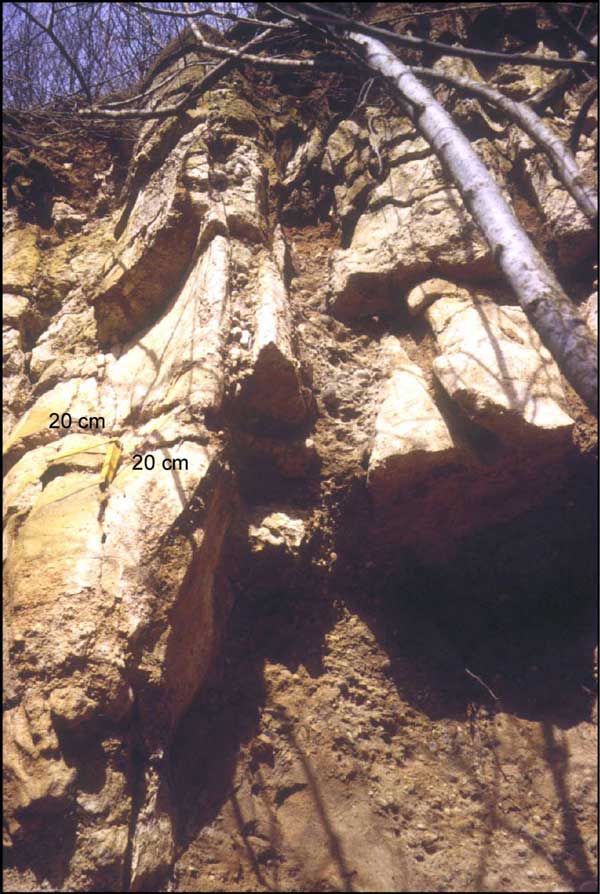
Photo 13. Karst pipes filled by some coarse alluvial deposits, in the old quarry of Pierre-la-Treiche (snapshot B.L.).
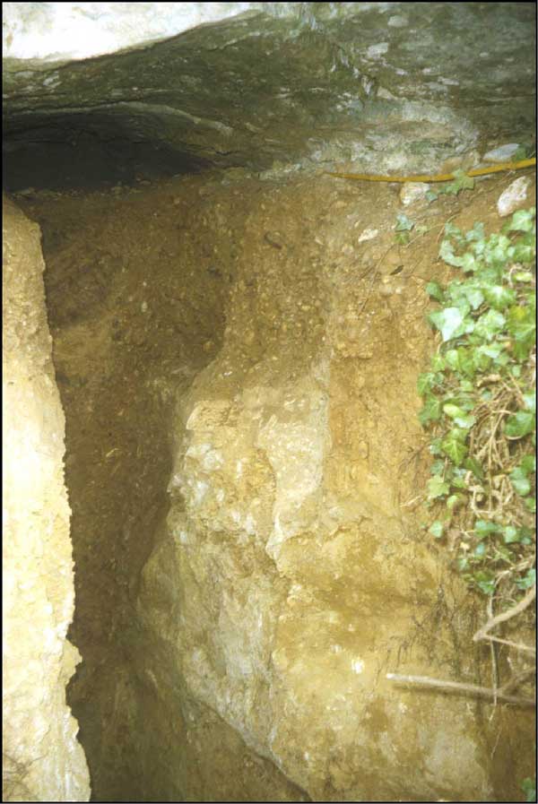
Photo 14. The entrance of Sainte-Reine Cave, filled at 90 to 100 % by the Moselle alluvial deposits (probably F4); the total infilling thickness exceeds 7.5 m (scale given by the folding double rule on the right) (snapshot B.L.).
These observations are borne out at all levels of karst cavities, along the cataclinal Moselle course as well as the anaclinal one, after the capture; the sole "Trou des Fees" ("Hole of Fairies") is appearing on the map of Fig. 3, but others cavities exist, like the "Trou de la Grosse Roche" ("Hole of the Big Rock"), for example.
It is interesting to notice that the karst at the lithostratigraphic contact, so well represented elsewhere in Lorraine (Gamez, 1992; Nicod, 1994; Jaillet and Gamez, 1995; Jaillet, 1999, 2000), is curiously lacking here or is not yet known, in spite of favorable geomorphologic conditions.
2.2. Chronological considerations: relative conception.
The only available temporal framework for the speleogenesis period resulted until then from an investigation of the relations between underground and surficial alluvial deposits, in order to refer to the relative chronology, which the fluvial deposits set up. Actually, the decreasing stepping in function to the age of the different alluvial levels (residual superficial deposits or real terraces) appears to be indisputable.
The petrographic differentiation that exists between ante- and postcapture alluvia (Harmand et al., 1995a), has allowed specifying the minimum relative age of many karst cavities, in which some fluvial surficial sediments have been analysed (Losson, 2000). The very great majority of the caverns of the Moselle valley contain alluvia coming from F4 (T 1.2 terrace) or older deposits. Here, the elevation of the cave systems is not correlative to the levels of fluvial terraces at all, because of their subfluvial genesis. So the karstification has taken place mostly before the Moselle diversion (along the cataclinal course at least), and at a significant depth under the thalweg for some caves (10 m at least), since we can see antecapture diluvium at an elevation similar to the lower terrace T 0.2 (cf. Fig. 4).
The speleothems of the caves allow to give chronological data to this change, and therefore to the capture.
3. The U/Th dating: a tool for paleogeomorphology
Eight stalagmites or flowstone floors, collected at various elevations in the different cave systems of the Moselle valley, have been dated by the U/Th method in the C.E.R.A.K. ( Mons, Belgium). The 26 isotopic analyses which have been carried out, have supplied 4 main classes of ages:
- ages similar to or higher than the maximal range (230Th/234U=1): about 270,000 years old and more than 350,000 years old;
- about 170,000 years old;
- in the Upper Pleistocene (about 40-50,000 years old);
- in the Holocene (less than 15,000 years old). The most interesting speleothems in this study are the ones whose age equal or exceed 170,000 years old (Table 1). Several chronostratigraphic and speleogenetic reasons relate to that.
In order to date the Moselle diversion as precisely as possible, it is necessary to be fit with the phenomenon, that is to collect the speleothems on stratigraphic conformability with the underground fluvial deposits which surround the capture (F3 and F4). We did not found any speleothems overlying the postcapture alluvial deposits F3 that would allow to supply a minimum age of the diversion right away. We must content ourselves with speleothems whose location on antecapture alluvia doesn't allow determining the anteriority or the posteriority of the hydrographic phenomenon toward the growth of speleothems. Indeed, the concretions give only a minimum date to the speleogenesis and to the setting up of the underlying filling. So, without further case, the capture can be younger or older than the dated speleothems, according to the time span from their development to setting up of the fluvial deposits.
In order to try to solve this problem, it is then necessary to take a new element into consideration: the essential draining of the galleries in which the speleothems have grown. This draining, which corresponds to a fall of the water table in the Bajocian limestones, varies, on the whole, according to the entrenchment of the main valleys (of the Meurthe and of the Moselle, that constitute the local base levels). Thus, we tackle the altimetric aspect of speleothems: the lower a speleothem is in elevation, the more likely it has grown late, when the water table has fell with the entrenchment of the valleys. If we manage to demonstrate that the low-lying concretions have grown after the capture (when the draining has occurred), we can deduce that this hydrographic diversion is older than speleothems. To sum up, the choice of the concretions for our demonstration was motivated by their age (the Moselle piracy we want to date definitely occurs before the Upper Pleistocene) and by their lowest elevation we were able to find in the valley. The other datings, which give much younger ages, will be analysed within the framework of another research issue, more targeted on the paleoclimate.
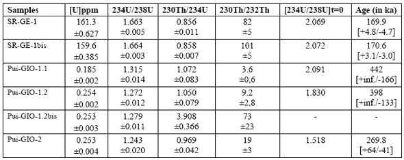
Table 1.
Results of the dating made by the C.E.R.A.K. (Polytechnic Faculty of Mons, Belgium); founding: C.E.G.U.M. ( University of Metz, France). The analyses are made in alpha spectrometry. This method sometimes leads to poor chemical yields, above all in thorium (recovery ratio of the element during the chemical preparation). The use of the isotopic dilution method (addition of an artificial isotope of the uranium and the thorium before this preparation) allows to free oneself from these losses. Nevertheless, a too important loss makes the analytical mistake very significant and considerably reduces the reliability of the age found.
3.1. The SR‚GE stalagmite
This speleothem (Photo 15), collected in Sainte-Reine Cave at an elevation of about 214 m, was unfortunately not in place, but has probably undergone limited displacement (Figures 6 and 7). Its isotopic analysis is very good and gives a great reliability to the obtained age, thanks to the strong uranium and low detritic thorium content.
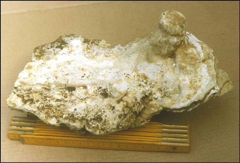
Photo 15. The SR‚GE‚1 stalagmite taken from Sainte-Reine Cave (snapshot B.L.).
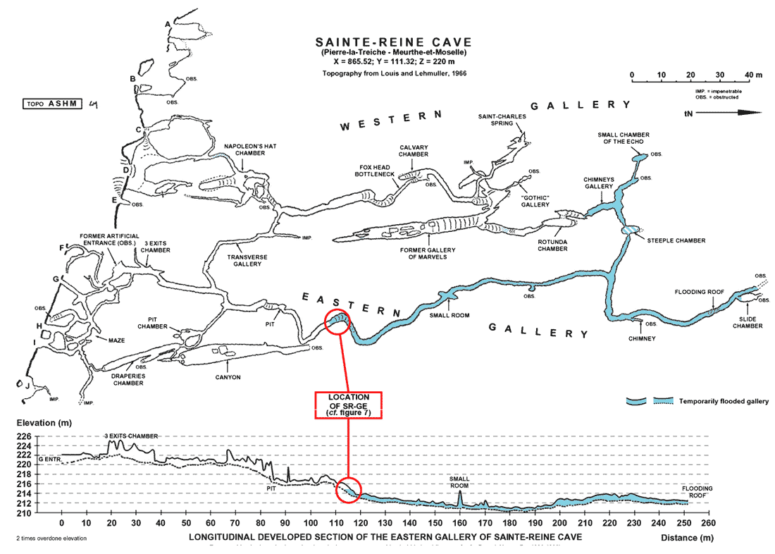
Fig. 6. Topographic and altimetric location of the SR‚GE stalagmite in Sainte-Reine Cave (Pierre-la-Treiche).
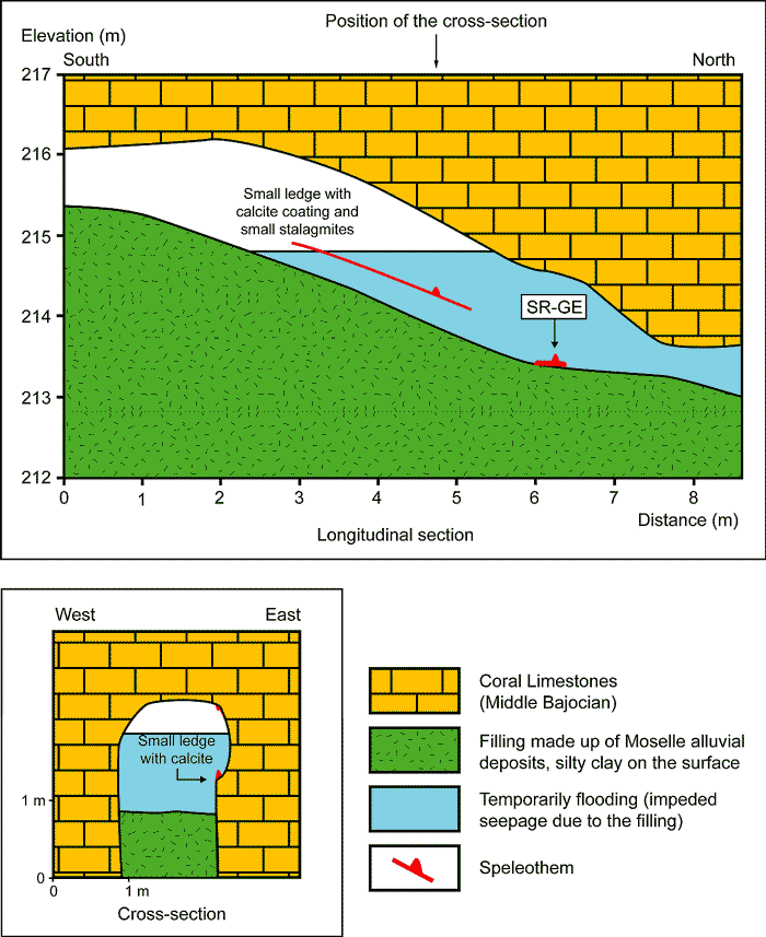
Fig. 7. Detail of the SR‚GE stalagmite sampling area in Sainte-Reine Cave (Pierre-la-Treiche).
According to its existence and its location, we can draw two conclusions: the gallery where it stood, was drained at the time of its growth, that is 170,000 years ago; the underlying sediments were set up at an even more former period; it can be assigned to F4 or older alluvia according to sedimentologic studies realised elsewhere in the cave (Gamez and Losson, 1998; unpublished observations). Let us notice that the speleogenesis occurred, on the whole, earlier than the filling deposition (Losson, 1999).
Many interpretations about the date of the Moselle capture may be set out on the basis of these findings, that is according firstly to the type of the karst alluvial deposits and secondly to the elevation of the water table under the thalweg.
Let us consider first a cave filling made of F4 alluvia. The growth of the SR‚GE stalagmite, 170,000 years ago, could be (Fig. 8) most early at the end of the F4 surficial aggradation (the time of the capture). In that case, the capture would have happened about 170,000 years ago; or else at a later stage of surficial incision or aggradation. The capture would have happened more, or even decidedly more, than 170,000 years ago.
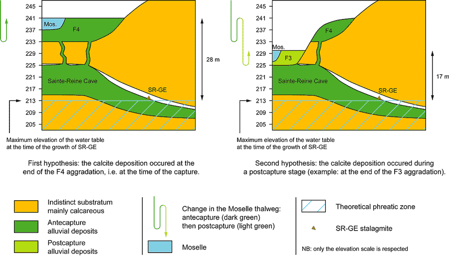
Fig. 8. Simplified representation of the geomorphologic and hydrogeological context in which the SR‚GE stalagmite has grown, according to two hypotheses.
The second hypothesis appears to be the most reliable. Indeed, in the first case, the water table would have been -28 m high under the thalweg, at the highest elevation. On the other hand, in the second case, it could reach a lower relative elevation under the thalweg. Now, a water table lower than -20 m below the thalweg, at that time, seems to be inconceivable to us, considering the supposed regional geomorphologic context, that governs the existence of exsurgences of the Bajocian limestones aquifer.
Let's now consider a cave filling made of F5 alluvia. The valley was less entrenched at the time of their surficial aggradation. So, if we keep the hypothesis of a water table that is not more than -20 m under the thalweg, we come to the conclusion that the SR‚GE stalagmite has grown after the end of the F4 surficial deposition, that is after the capture.
Thus, in every case, we get back to an age older than 170,000 years for the hydrographic diversion.
In addition, it is interesting to note that the speleothem growth period corresponds to a short warming stage ( 18O isotopic stage 6.5; Martinson et al., 1987). So, it is possible that the Moselle fluvial landscape has not kept any geomorphologic witness correlative to this period. In these conditions, the development of the stalagmite would relate to any surficial known parameter.
3.2. The Pui-GIO flowstone floor
This speleothem (Photo 16) collected in Shafts Cave, was at an elevation of 226 m (Fig. 9). Pui-GIO-1 and Pui-GIO-2 are two pieces of a same flowstone floor whose respective position in the gallery differed: the first one lay on the floor (silty clay filling), whereas the second one was still perched on the wall, a few centimetres above the filling (Fig. 10). More precisely, Pui-GIO-2 is the equivalent of Pui-GIO-1.2. Some metres southwards in the gallery, we find this same flowstone floor again, hanged more than 1 m above the withdrawn filling (Photo 17).
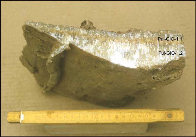
Photo 16. The Pui-GIO-1 flowstone floor taken from Shafts Cave; on the left, note the calcite infilling inside a desiccation crack (snapshot B.L.).
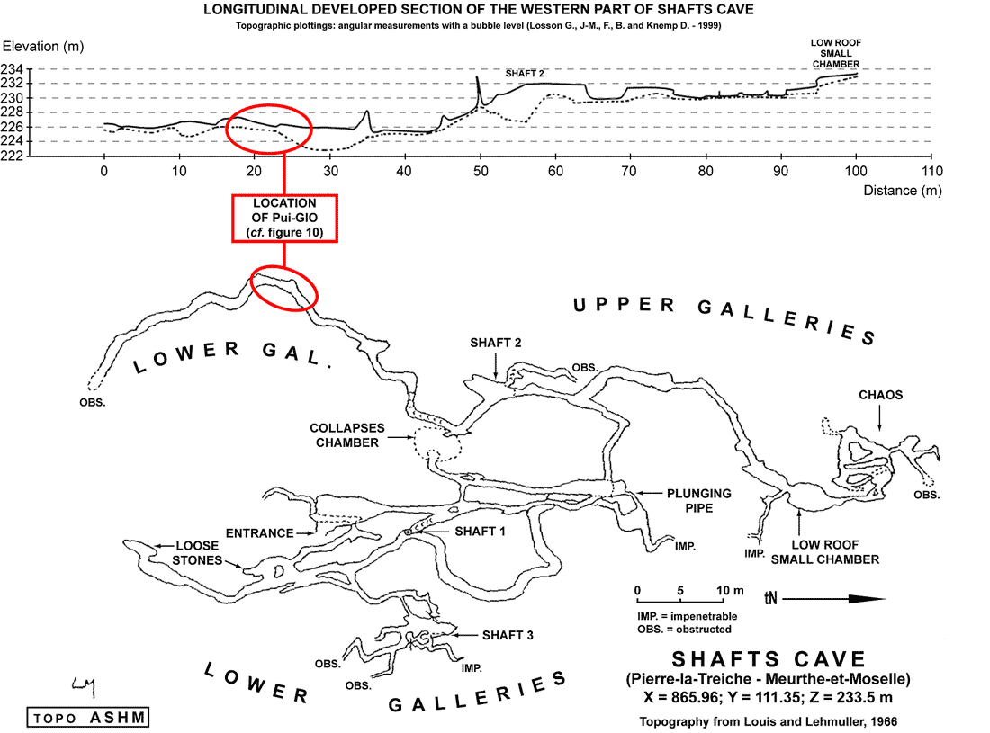
Fig. 9. Topographic and altimetric location of the Pui-GIO flowstone floor in Shafts Cave (Pierre-la-Treiche).

Fig. 10. Detail of the Pui-GIO flowstone floor sampling area in Shafts Cave (Pierre-la-Treiche).
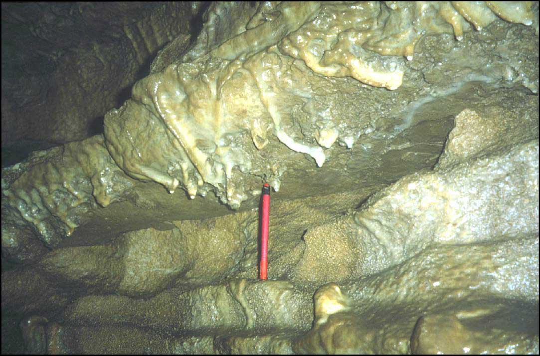
Photo 17. A hanging flowstone floor in the western Lower Gallery of Shafts Cave, probably a lateral equivalent of Pui-GIO-1 and Pui-GIO-2; the small calcite cylinder, just above the felt-tip, reveals a former underlying sandy infilling (snapshot B.L.).
The analyses of the first two samples (cf. Table 1), in a stratigraphic succession, are good but they have some quite small isotopic ratios 230Th/ 232Th. It must be known that this ratio indicates the possible contamination of the speleothem by unfamiliar substances to the carbonated system. We experimentally estimate that the value of this ratio must exceed 20 for the result to be correct. Here, the value of 9 and, all the more so, of 4, is small. The 270,000 years old Pui-GIO-2 is more reliable, because of a higher isotopic ratio 230Th/ 232Th. The consideration of these three results leads us to a position this flowstone floor is about 300,000 years old. The sample Pui-GIO-1.2bis is characterized by a very bad yield on the thorium: the result must be ruled out.
Some identical conclusions to those of Sainte-Reine's stalagmite can be deduced for this speleothem: drained gallery at the time of the calcite deposition, at least 300,000 years ago; a former deposition of the underlying sediments; these ones have unfortunately not been determined near the concretion; probably even former speleogenesis.
This old flowstone floor allows some corrections about the previous interpretations. Indeed, Shafts Cave and Sainte-Reine cave systems are only 400 m apart (cf. Fig. 5). Now, if we take the morphosedimentary study of Sainte-Reine Cave E Entrance into account (Gamez and Losson, 1998), where the F4 (or ante-F4) alluvial deposits are up to 225 m high, it can be reasonably thought that the gallery which contains Pui-GIO has been drained after the accumulation of these Moselle detritic deposits in Sainte-Reine Cave. As a consequence, it would be possible to replace the age of 170,000 years old of the previous interpretations with this of 300,000 years old. So, the Moselle piracy would have occurred more, or even more, than 300,000 years ago.
Taking up the North European nomenclature, we can note that the capture would not relate to the Saalian glaciation, as admitted since J. Tricart works (1952), but to a stage of the Holsteinian interglacial at least, if not to the Elsterian glaciation (cf. Sibrava et al., 1986, in Conchon, 1992; Renault-Miskovsky, 1992). However, to be true, this remark would require to know the real temporal period for these terms of Saalian, Holsteinian and Elsterian. Some divergences of interpretation exist between different authors, in particular for the limit Holsteinian/Elsterian.
Conclusion
Like many researches have already emphasized (Maire, 1990; Audra, 1994; Delannoy, 1997; Vanara, 2000; Jaillet, 2000), the karst environment has been proved to be of an unequalled wealth for all kinds of paleogeographic reconstructions. As regards to caves of the Moselle valley, of which a little part of the morphosedimentary information only have been mentioned here, some new chronological data have been revealed.
The speleogenesis of the concerned cavities by the U/Th dating goes obviously back to a former period than 300,000 years old, like the Moselle piracy phenomenon, and we couldn't be more specific. This result relies on established interdependencies between different parameters of the physical environment: elevation, superposition, morphologic and sedimentologic indications concerning the alluvial deposits and the endokarst. Chronological and geomorphologic correlations with the results of S. Jaillet (2000) about the entrenchment of the streams of Barrois (western Lorraine), are still impossible to establish, in the present state of our knowledge. On the other hand, the proposed interpretations seem to be confirmed by other U/Th datings obtained in Belgium in the Meuse watershed. Indeed, many speleothems close to the present streams in elevation, have supplied ages older than 400,000 years (Quinif, 1999). This means the Meuse and its tributary rivers have practically halted their entrenchment since that time, which really happened on the upper part of the stream after the Upper Moselle piracy (Harmand, 1992; Pissart et al., 1997). As the last stage of notable entrenchment of the Meuse valley goes back to the immediately antecapture period, this major hydrographic diversion would have occurred between 300,000 and 400,000 years old at least. In addition, these results confirm and support the only absolute dating related to the Moselle piracy available until then. It was a 250,000 ± 20,000 years old minimal age obtained by thermoluminescence on burned flints, in the Meuse valley in Maastricht (Huxtable and Aitken, 1985, in Harmand et al., 1995b). The accurate setting of the capture towards the fluvial terraces system in this area was established thanks to heavy minerals studies (Paulissen, 1973, in Harmand et al., 1995b). The flints lay, as for them, in a younger stratigraphic order than the mineralogical break (Vandenberghe et al., 1985). As a result, the Moselle diversion had been dated more than 250,000 years old, without possible further detail. Finally, we can notice that the chronological framework based on the North European glaciations and applied to the fluvial sediments, is less valid with the increase in absolute dating. So, it seems to be desirable to adopt in a first time a specific nomenclature to each main river basin (terraces T 0.1, T 1.2, T 1.1, Ö and alluvial deposits F3, F4, F5, Ö for example), and then to refer preferably to the 18O isotopic stages (Shackleton and Opdyke, 1973; Martinson et al., 1987) as long as absolute dating is available.
We dedicate this article to Patrice Gamez, originator of the dating project. His memory led us all the way through this work and we regret he didn't assess the results.
Acknowledgements
We are grateful to Jean-Jacques Delannoy, Richard Maire and Jean Nicod for the improvements they made to the initial version of this article. In addition, we have received essential information about the researches in the Maastricht site, thanks to Messrs Harmand and Pissart good offices.
References
- Audra, P. 1994. Karsts alpins; genese des grands reseaux souterrains. Exemples: le Tennengebirge (Autriche), l'Ile de Cremieu, la Chartreuse et le Vercors (France). Karstologia Mem. 5, 280 p.
- Blache, J. 1939-1940. Le probleme des meandres encaisses et les rivieres lorraines. J. of Geomorphology 2(3), 201-212 and 3(4), 311-331.
- Blache, J. 1943. Captures comparees: la vallee morte de la Bar et les cas voisins. Rev. Geogr. Alpine 31(1), 1-37.
- Buvignier, A. 1840. Note sur les alluvions de la Moselle dans la vallee de la Meuse. Mem. Soc. Philomathique de Verdun ( Meuse) 1, 255-258.
- Conchon, O. 1992. Que sont Gunz et Mindel devenus? Approches recentes de la stratigraphie du Quaternaire. In: A propos du Quaternaire en Europe, Geochronique 44, 16-18.
- Dangana, L.B. 1970. Les terrasses de la Moselle entre Neuves-Maisons et Toul. Master's Univ. Nancy 2, 131 p.
- Davis , W.M. 1895. La Seine, la Meuse et la Moselle. Ann. Geogr., 25-49. Delannoy, J.-J. 1997. Recherches geomorphologiques sur les massifs karstiques du Vercors et de la Transversale de Ronda (Andalousie). Les apports morphogeniques du karst. Doctoral Thesis Univ. Grenoble 1, Villeneuve d'Ascq, P.U.Septentrion, 678 p.
- Dorniol, Y. 1997. Etude morphologique de la vallee de la Moselle entre Neuves-Maisons et Chaudeney-sur-Moselle. Master's Univ. Nancy 2, 108 p.
- Emiliani, C. 1955. Pleistocene temperatures. J. of Geology 63, 538-578.
- Errard, S. 1942. Le probleme de la ´ capture ª de la Moselle. DES hist.-geo. Univ. Nancy, 217p.
- Fenelon, P. 1968. Vocabulaire francais des phenomenes karstiques. Mem. et Doc. 4, 13-68.
- Gamez, P. 1992. Hydrologie et karstologie du bassin du Loison (Woevre septentrionale - Lorraine). Doctoral Thesis Univ. Metz, Mosella 21, publ. 1995, 453 p.
- Gamez, P., Wehrli, A., Fizaine, J.-P., Scapoli, J. 1995. Líimplication du karst dans la capture de la Moselle. Rev. Geogr. de l'Est 35(3-4), 297-308.
- Gamez, P., Losson, B. 1998. Premiers resultats de l'etude des remplissages dans le karst de Pierre-la-Treiche (54); l'entree E du reseau Sainte-Reine. Mosella 23(3-4), 41-59.
- Gardet, G. 1928. Les systemes de terrasses de la trouee Pont-Saint-Vincent, Toul, Foug, Commercy. Bull. Soc. Sci. Nancy 4(3)(3), 237-280.
- Harmand, D. 1992. Histoire de la vallee de la Meuse lorraine. P.U.Nancy, 146 p.
- Harmand, D., Kartit, A., Occhietti, S., Weisrock, A. 1995a. Líage de la capture: correlations entre les formations fluviatiles saaliennes de la Haute Moselle et de la Meuse. Rev. Geogr. de l'Est 35(3-4), 269-290.
- Harmand, D., Krook, L., Pissart, A. 1995b. Líenregistrement de la capture de la Haute Moselle dans les alluvions de la basse vallee de la Meuse. Rev. Geogr. de l'Est 35(3-4), 291-296.
- Harmand, D., Weisrock, A., Gamez, P., Le Roux, J., Occhietti, S., Deshaies, M., Bonnefont, J.-C., Sary, M. 1995c. Nouvelles donnees relatives a la capture de la Moselle. Rev. Geogr. de l'Est 35(3-4), 321-343.
- Harmand, D., Pissart, A., Krook, L. 1998. L'evolution du paleo-bassin de la Meuse: les enseignements des captures et leurs implications environnementales. In: Arbeiten aus dem Geographischen Institut der Universitat des Saarlandes. Symposium ´ Problemes de l'environnement en Saar-Lor-Lux ª, Sarrebruck, 157-173.
- Harmand, D., Le Roux, J. 2000. La capture de la Haute Moselle. Bull. Inf. Geol. Bassin Paris 37(3), 4-14.
- Husson, N. 1864. Origine de líespece humaine dans les environs de Toul par rapport au diluvium alpin. Pont-a-Mousson, print. P. Toussaint, 63 p.
- Jaillet, S. 1999. Recul de couverture et karstification dans un karst couvert de bas plateaux: le Barrois ( Lorraine / Champagne - France). Actes du Colloque europeen Karst 99, Etudes de geographie physique suppl. 28, 123-128.
- Jaillet, S. 2000. Un karst couvert de bas-plateau: le Barrois ( Lorraine / Champagne, France). Structure - Fonctionnement - Evolution. Doctoral Thesis Univ. Bordeaux 3, 710 p.
- Jaillet, S., Gamez, P. 1995. Observations morphologiques sur le geosysteme karstique du Rupt du Puits ( Meuse, Lorraine). Karstologia 26, 27-38. Le Roux, J.,
- Harmand, D. 1998. Controle morphostructural de l'histoire d'un reseau hydrographique: le site de la capture de la Moselle. Geodinamica Acta 11(4), 149-162.
- Losson, B. 1999. Apercu karstogenetique de la grotte Sainte-Reine ( Lorraine, France). Regards 37, 29-32.
- Losson, B. 2000. Modalites des defluviations partielles souterraines de la Moselle avant sa capture. Bull. Inf. Geol. Bassin Paris 37(3), 15-22.
- Louis, M. 1988. Retrospective d'une decouverte: grotte des 7 Salles, Pierre-la-Treiche. Speleo L 14, 31-35.
- Louis, M., Lehmuller, D. 1966. Contribution a l'avancement du catalogue des cavites de Meurthe-et-Moselle. Roneo, 137 p.+34 pl.
- Macaire, J.-J. 1990. Líenregistrement du temps dans les depots fluviatiles superficiels: de la geodynamique a la chronostratigraphie. Quaternaire 1(1), 41-49.
- Maire, R. 1990. La haute montagne calcaire: karsts, cavites, remplissages, quaternaire, paleoclimats. Karstologia Mem. 3, 732 p.
- Martin, P. 1920. Sur la jonction ancienne de la Moselle et de la Meuse par le Val de l'Ane. Bull. Soc. Sci. Nancy 4(1), 181-189.
- Martinson, D.G., Pisias, N.G., Hays, J.D., Imbrie, J., Moore, T.C., Shackleton, N.J. 1987. Age dating and the orbital theory of ice ages: development of a high resolution 0 to 300,000 year chronostratigraphy. Quaternary Research 27(1), 1-29.
- Nickles, R. 1911. Contribution a la connaissance de la jonction ancienne de la Moselle et de la Meuse par le Val de l'Ane. Bull. Seances Soc. Sci. Nancy 3(12)(1-4), 282-287.
- Nicod, J. 1994. Plateaux karstiques sous couverture en France, díapres des travaux recents. Caracteres geomorphologiques et problemes díenvironnement. Ann. Geogr. 576, 170-194.
- Pissart, A., Harmand, D., Krook, L. 1997. Líevolution de la Meuse de Toul a Maastricht de puis le Miocene: correlations chronologiques et traces des captures de la Meuse lorraine díapres les mineraux denses. Geogr. Phys. et Quat. 51(3), 267-284.
- Quinif, Y. 1989. La datation uranium-thorium. Speleochronos 1, 3-22. Quinif, Y. 1999. Karst et evolution des rivieres: le cas de líArdenne. Geodinamica Acta 12(3-4), 267-277.
- Renault-Miskovsky, J. 1992. La palynologie du Quaternaire europeen: chronostratigraphie - paleoclimatologie et paleoenvironnement vegetal de líhomme fossile. In: A propos du Quaternaire en Europe, Geochronique 44, 21-24.
- Shackleton , N.J., Opdyke, N.D. 1973. Oxygen isotope and palaeomagnetic stratigraphy of equatorial Pacific core V28-238: oxygen isotope temperatures and ices volumes on a 105 year and 106 year scale. Quaternary Research 3(1), 39-55.
- Taous, A. 1994. Le systeme alluvial de ´la moyenne terrasse ª de la Moselle en Lorraine meridionale (approche morphosedimentaire et petrographique). Doctoral Thesis Univ. Nancy 2, 201 p.
- Techer, P. 1995. Etude morphologique et petrographique du complexe alluvial de la moyenne terrasse sur le site de capture de la Moselle. Master's Univ. Nancy 2, 113 p.
- Theobald, N., Gardet, G. 1935. Les alluvions anciennes de la Moselle et de la Meurthe en amont de Sierck. Bull. Centenaire Soc. Hist. Nat. Moselle 34, 69-100.
- Tricart, J. 1952. La partie orientale du bassin de Paris. Etude morphologique. Paris, S.E.D.E.S., 474 p.
- Vanara, N. 2000. Le karst des Arbailles. Karstologia Mem. 8, 320 p.
- Vandenberghe, J., Mucher, H. J., Roebroeks, W., Gemke, D. 1985.
- Lithostratigraphy and palaeoenvironment of the Pleistocene deposits at Maastricht-Belvedere, southern Limburg, the Netherlands: stratigraphy, palaeo-environment and archaeology of the middle and late Pleistocene deposits. Mededelingen rijks geologische dienst 39(1), 7-18.
- Vaskou, P. 1979. Contribution a la classification des formations alluviales de la feuille de Toul au 1/50 000eme. D.E.A. Univ. Nancy 1, 57 p.+12 pl.
- Vidal de la Blache, J. 1908. Etude sur la vallee lorraine de la Meuse. Paris, A. Colin, 189 p.